|
|
[Editor's note: My comments are in square brackets - Wendy]
June 19, 2001 - North of Etna-Hanover Center Road
Miles: 20.5 Time 12 hr
Since I had a mail drop to pick up and a resupply to do, I was going to take a little shorter day today. I also wanted to do a laundry and a little mending. Upon getting to Hanover, Johnny Looksee and I went to Dartmouth's Outing Club headquarters to see about possible accomodation on campus. It turns out that three of the fraternities offer rooms overnight to hikers, but school was not currently in session , so nobody knew what, if anything, was available. The only way to find out was to go to each fraternity individually. Johnny elected to do so. I opted out, did my mail and resupply, and headed for Velvet Rocks shelter. (No laundry - would you believe a place the size of Hanover has no laundromat?)
My only reason for going to shelters, especially in good weather, is a reliable water source. Velvet Rocks has one but it is 0.5 miles further north on the AT and 0.2 miles off the trail. This combined with 0.2 miles from the AT to the shelter puts the water nearly a mile away. So, I just kept walking until I found water along the trail, filled both my bottles, and stopped at the first suitable spot after that.
The mosquitos have been pesky all day and there has been a cloud of them around me this evening. I keep destroying them. There are scores of tiny dead bodies around. But they just keep coming. I think they have the full power of the Krell machines at their disposal [paraphrased from "Forbidden Planet" - "That machine is going to supply those mosquitos with whatever power they require to reach you!"].
I am done with Vermont and about six miles into New Hampshire.
June 20, 2001 - South Jacob's Brook
Miles: 21.4 Time: 12.25 hr
I was just thinking today as I fought my way through the overgrown brush that, in my four hikes through NH, I had never seen any evidence of recent routine maintenance in the DOC sections. Suddenly, I came to a long stretch that had been weed-whacked and pruned, and, at the end of that stretch, four DOC maintainers weed-whacking and pruning.
The trail goes over Holt's Ledge, which is supposed to have good views, but most of the area was off-limits to prevent disturbing nesting Peregrine Falcons. The only real effort for the day was going over Smarts Mountain.
When I first got to where I wanted to camp, I was amazed that nobody had camped here before. It is by a rushing brook with nice pools. But closer inspection revealed a previously used site just downstream on the north side of the stream.
I walked almost the whole season of Spring and now it's Summer, but I don't remember any Spring weather. It was Winter up until Damascus, then it became Summer.
June 21, 2001 - Welcome Hiker Hostel
Miles: [?] Time: 10 hr
Just as I reached the crest of Ore Hill today, I flushed a bunch of baby grouse. They flew cheeping in all directions. I once again got the hiss and fan-tail from momma. I notice that she also has a ring of feathers around the neck that she can raise to help make her look big and fierce.
I stopped at the Glenncliff Post Office to mail a letter. They have a little hiker area set up outside with various postal supplies, address labels, tape, etc.
Just across the road is this hostel. I stopped in to check it out and decided to stay. I finally got my laundry done. Also here at the hostel are section hikers Matt (southbound), Clyde (northbound), and Heather ("The Garlic Girl", northbound). Today is "Hike Naked" day, but I didn't even consider it because of the bugs. Heather did observe it, "except at road crossings".
June 22, 2001 - Eliza Brook Shelter
Milestone: 3 Calendar Months
Miles: 17 Time: 11.5 hr
It sprinked on and off yesterday evening and last night. This morning was heavily overcast and the forecast was for rain today and tomorrow. The rain today never materialized, but I got no view from Mooselauke, just chilling high wind and fog. I paused only briefly at the summit to check the direction signs to be sure I knew how to get the heck out of there.
I saw only two dayhikers all day yet there are 14 people and a dog here at the shelter. (I am camped away from the shelter, of course). I'm pretty sure 9 of them are all in one group.
[Curt's journal gets a little sketchy at this point. I'm missing entries from June 23 and 24, and Curt reconstructed June 25-28 from notes he took while slackpacking in the Whites. Maybe he'll be able to reconstruct everything when he gets home - which is SOON now, yikes!]
June 25-28, 2001 - Gorham, NH
Miles: 78.2 Time: 4 days (details below)
One problem I always have when I stay in a town is that I seldom keep up with my journal while there. A stay of several days like this is particularly bad because my memory of events and even the order of those that I remember is pretty poor. But, I will try to summarize the important points.
When I arrived in Gorham, I immediately found a space at the "Hiker's Paradise" hostel. This hostel is in an old house and has separate rooms, usually with four bunks, affording a bit more privacy than the other hostel in town ("The Barn"), which simply has a loft with bunks. I was fortunate enough to obtain a small room that had only two bunks and I had it all to myself for the entire stay.
My next order of business was to try to find a new pair of boots. One would think that this would be easy in a town with two outfitters and a sports shoe store. Unfortunately, my feet are not a very common size [10 1/2 with as many E's as you can possibly add at the end] and only the shoe store had anything that would fit me. The fits turn out to be four types and styles of Nike New Balance (TM) shoes, none of which were real hiking boots. I finally settled for a pair of low-cut running shoes. This was not the ideal but thery are very comfortable and relatively inexpensive.
At the hostel the first night were "Doc Savage", "Uncle Shoe", "Tabasco", and two others whose names I did not get. At his insistance, I played Doc two games of chess, the first I have played in many, many years (against a human, anyway). [Who won?]
It turns out that Doc and Shoe were taking advantage of the hostel's shuttle service to "slack pack" sections of the trail around Gorham. Slackpacking is the practice, disapproved of by some hikers, of being shuttled about so that one can hike sections of the trail with just a daypack rather than a fully loaded backpack. The long distance hiker can take advantage of this to either walk more miles with the same effort or to get a little bit of rest by hiking the usual number of miles with less effort. For me, there were also the advantages of bypassing the restrictive camping rules in the White Mountains and trying out the new shoes without the extra stress of a heavy pack. I did three slack days plus a day off. The slack days in trail order, not day order were:
Crawford Notch to Pinkham Notch
Miles: 26.0 Time: 14.25 hr
I was accompained on this section by Shawna ("Dismount") and Owen ("Blowdown"), a young couple who are either the first and second or the second and third "real" southbound thruhikers. I use the "real" qualifier because the situation is confused this year. Late snow kept Katahdin closed and a couple dozen southbounders simply started south without climbing it.
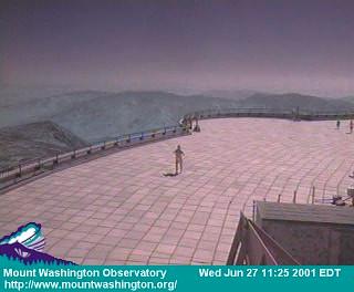
We took a long lunch break on top of Mt. Washington during which I phoned Wendy to see if she could capture me on the Mt. Washington Obervatory "web-cam".
Although a bit windy and very crowded, it was a good day to hike the Presidentials. Ran into Garlic Girl, who had worked for stay at Mitzpah Hut.
Pinkham Notch to Rt. 2
Miles: 21.1 Time: 10 hr
This is the tail end northbound of the Presidentials. There are a number of climbs, but in all, there is a loss of 1275 feet altitude. It's really not a very notable hike. The Rattle River shelter near the northern end is in a nice site by a stream with deep pools and brook trout.
Rt. 2 to Grafton Notch
Miles: 31.1 Time: 14.5 hr
Flower: White Lady Slippers
Bird: Spruce Grouse
This section was actually done north to south at a breakneck (almost literally, a couple of times) speed for the terrain. It includes the infamous Mahoosic Notch, a mile of trail covered with car-sized boulders sandwiched between two high, nearly vertical rock walls. Even at maximm effort, that one mile took me over an hour. There was a lot more ice and snow (always present in the notch) than I have seen in previous trips, but it was not enough to add to the difficulty. In theory , I was hiking this section with "Tabasco", but I got ahead of him in the first ten minutes and he never caught up.
In no particular order, other hikers who stayed at the hostel during the time I was there are Shadowman, AT Chaz, Sun Dog, Johnny Looksee, and Shamus.
In the end I found the new shoes fine for day hiking but probably inadequate for backpacking. I resurrectied my old boots and will bear with them until my Monson mail drop.
June 29, 2001 - Hall Mountain Shelter
Miles: 16.3 Time: 11.5 hr
The hostel cleared out this morning with Shamus and Johnny getting on at Rt. 2, Dismount and Blowdown at Crawford Notch, and myself at Grafton Notch.
It was quite literally a very quiet day. It as overcast and cool with little wind and even the birds seemed subdued.
Shadowman is here at the shelter and a section hiker ("Tinman") is camping nearby.
June 30, 2001 - Near ME Rt 17
Miles: approx. 19 Time: 11 hr
Snakes: 1
Birds seen (s) and heard (h): Canada Jay (s)
The Canada Jays were the only real excitement for the day. I came over a little rise while climbing Bemis Mt. and there were three of them directly on the trail. All three flew off, but two of them went no further than the nearby brush and squawked and fussed at me as I went by. I think the third was a fledgling and these two were the parents. I've been threatened by a lot of birds on this trip. Hmmm. That might make a good movie plot.
A fawn, still bedecked in speckled fur, just ran by within 20 feet of my camp site.
July 1, 2001 - Poplar Ridge Shelter
Miles: 22.2 Time: 13.5 hr
This was walking stick adjustment day. After stumbling up and down a few steep grades, I finally pitched the second pole that I had been using since Pennsylvania into the woods. Going back to a single pole immediately demonstrated that the wear-shortened remaining pole that I had carried since (? - way down south) was inadequate, and it too was left behind as soon as I found a suitable substitute.
Once I was "repoled" and back using single pole techniques, the hike seemed to be easier and faster, but maybe it's just the fact that I'm back to methods that I've used for years.
[I don't yet have trail journal entries from here to Monson. Curt or I will add them when available.]